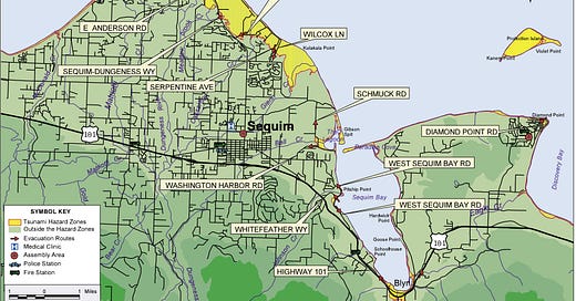
Towne Road as a tsunami evacuation route
State agency aware of County’s pending decision
There has been much speculation whether the new Towne Road Levee will be designated as a tsunami evacuation route for communities that lie in the hazard zone to the north. The County’s progress in seeking this designation has been hard to measure but in June, Commissioner Ozias had this to say to an inquisitive resident:
"We are also working with the appropriate state and federal agencies to do new modeling so that we can better understand whether Towne Rd, if on top of the levy, would serve as a Tsunami evacuation route.” — Mark Ozias, June 15th, 2023
Three months later, at a public meeting held in Sequim, County Biologist Cathy Lear was asked if the new Towne Road was designated as a tsunami evacuation route. She replied, “No.” A followup question asked if the County had even applied for tsunami evacuation designation. Lear hesitated before replying, “No.”
Just a week after that public meeting, during a Commissioners' Work Session, Commissioner Ozias asked whether the “new” Towne Road would be considered a tsunami evacuation route. He was unsure which department would best assign the possible evacuation route designation and he questioned, “who would be taking the lead?” It became evident that very little, if any, action had been taken to obtain evacuation route designation.
At Sequim’s recent Safety Fair, I connected with Elyssa Tappero, the Tsunami Program Coordinator for the Washington Emergency Management Division. I asked Elyssa what guidance a Program Coordinator would offer to County leaders who have struggled with the beginning stages of determining if Towne Road would serve as an evacuation route.
Elyssa Tappero’s reply further cements my belief that, if disaster strikes, Towne Road will be a crucial route of egress for hundreds of residents. Read Tappero’s email below.
—
"Hello again! Got some confirmation from the county, so here are my thoughts…
There are no formal requirements for what constitutes an evacuation route, at least not when it comes to the tsunami hazard – for a local tsunami preceded by a major earthquake, people will be evacuating on foot and so any walkable route can be a tsunami evacuation route, essentially. This particular point might be getting lost in the debate, since most people think of evacuation as something that always takes place in a vehicle, but in reality cars will be useless for a local event like a Cascadia Subduction Zone earthquake. And of course when the time does come for folks to evacuate, ANY road or route that gets you to safety is an option – designated evacuation routes just tend to be those that are the shortest, most accessible, or otherwise most obvious options in the area. But if getting to safety in the moment means crossing private property or doing something else not totally acceptable during normal times, that’s just what the moment calls for!
According to Ron Cameron, it sounds like no one is opposed to designating the road as a tsunami evacuation route, as this wouldn’t necessarily require it to be paved or otherwise open to vehicles. That being said, it also sounds like your local emergency management is in favor of the road being reopened to the public anyway to ensure folks in the area have as many evacuation routes (for any hazard) as possible and have shared this opinion with the county commissioners. Ron also asked for feedback from myself and Daniel Eungard from WA DNR, and we both said pretty much the same thing (more open roads = better evacuation), so he may have shared our insights with the commissioners as well.
I can’t remember if I mentioned this at the event, but we will likely be creating a tsunami pedestrian evacuation route map for the Dungeness area in 2024 (like the Port Angeles one). We will work with the county and other local stakeholders to ensure any and all desired evacuation routes are identified on it as either roads or trails/paths, so I have a feeling Towne Road will be on there as an evacuation route one way or another. Hopefully our timeline for production of the map helps move things along a bit for you all, or at least contributes positively to the discussion."


